- Feb 21, 2013
- 3,130
- 518
- 175
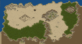
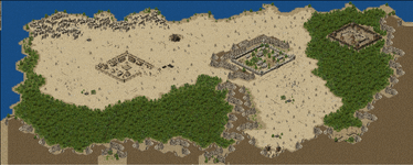
Fully zoomed out image in the MapEditor is stretched wide, see an example of Mongchon map here that is 1000x800 tiles size. Most maps have much smaller sizes and so the distortion is not as noticeable if you take screens of the fully or almost fully zoomed out maps for archiving purpose (when MiniMaps would be too small).
MiniMap:

Screenshot of Zoomed Out Map is the same vertical size but is stretched horizontally:

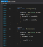
The code for zooming maps in & out is not too complicated for some 'error' to hide somewhere in there (at least from my non-coder view) but perhaps it is not what it does have as what it may not have, like it doesn't take into account something when resizing maps?

The references of the above zoom code point to nothing even remotely suspicious.
Also eliminated the suspicion I had - that rectangle sized maps result in uneven zoom ratio, like if Mongchon map is 1000x800 size, the longer horizontal size will result in more than proportionally longer zoomed out size along the x coordinate.
I found a map though that is a 'square', that is, has the same tile number in x & y coordinates, 1k x 1k size ('Hanhai Continent.map' from Fables Map Pack) and it is also stretched along x coordinate when fully zoomed out.
Maps with the same tile number along both x & y coordinates naturally form a rectangle since Tiles are 96x64 pixels with aspect ratio 3:2.
'Hanhai Continent.map' size shown in the MapEditor is 994 x 998 tiles
'Hanhai Continent'_MiniMap.png size is 1491 x 998 pixels, 3:2 tile aspect ratio.

'Hanhai Continent' Zoomed Out size is 1989 x 998 pixels which is aspect ratio ~2:1
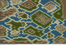
Screenshot from MapEditor, the x direction is longer by ~500 pixels relative to the MiniMap size, the y direction is the same.
![Hanhai Continent Zoomed Out Screenshot [Aspect ratio is OFF].jpg Hanhai Continent Zoomed Out Screenshot [Aspect ratio is OFF].jpg](https://www.lomcn.net/forum/data/attachments/18/18708-5527e3079258cd44972773605d7c1e1f.jpg)
This stretching really only matters if one wants to make a screenshot of the zoomed out map to include with the map for easy identification. For the purpose of seeing the whole map layout at a glance, it serves the function but the image distortion makes the map's detail quality pretty miserable.
MiniMap:

Screenshot of Zoomed Out Map is the same vertical size but is stretched horizontally:

The code for zooming maps in & out is not too complicated for some 'error' to hide somewhere in there (at least from my non-coder view) but perhaps it is not what it does have as what it may not have, like it doesn't take into account something when resizing maps?

Post automatically merged:
The references of the above zoom code point to nothing even remotely suspicious.
Also eliminated the suspicion I had - that rectangle sized maps result in uneven zoom ratio, like if Mongchon map is 1000x800 size, the longer horizontal size will result in more than proportionally longer zoomed out size along the x coordinate.
I found a map though that is a 'square', that is, has the same tile number in x & y coordinates, 1k x 1k size ('Hanhai Continent.map' from Fables Map Pack) and it is also stretched along x coordinate when fully zoomed out.
Maps with the same tile number along both x & y coordinates naturally form a rectangle since Tiles are 96x64 pixels with aspect ratio 3:2.
'Hanhai Continent.map' size shown in the MapEditor is 994 x 998 tiles
'Hanhai Continent'_MiniMap.png size is 1491 x 998 pixels, 3:2 tile aspect ratio.

'Hanhai Continent' Zoomed Out size is 1989 x 998 pixels which is aspect ratio ~2:1
Screenshot from MapEditor, the x direction is longer by ~500 pixels relative to the MiniMap size, the y direction is the same.
![Hanhai Continent Zoomed Out Screenshot [Aspect ratio is OFF].jpg Hanhai Continent Zoomed Out Screenshot [Aspect ratio is OFF].jpg](https://www.lomcn.net/forum/data/attachments/18/18708-5527e3079258cd44972773605d7c1e1f.jpg)
This stretching really only matters if one wants to make a screenshot of the zoomed out map to include with the map for easy identification. For the purpose of seeing the whole map layout at a glance, it serves the function but the image distortion makes the map's detail quality pretty miserable.
Last edited:

